Winter storm moves east Monday, bringing dangerous winds, snow and ice
A strong winter storm is centered over the Great Lakes Monday morning and a cold front is extending to the Gulf Coast, generating strong winds and rapid temperature changes for millions of people.
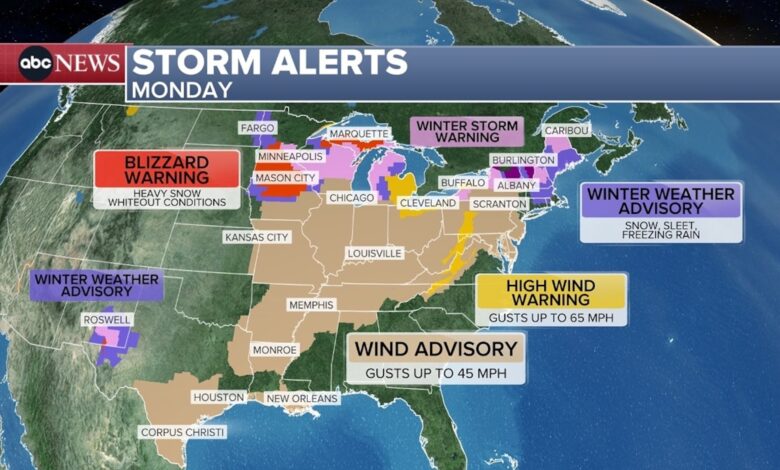
More than 125 million Americans are on alert today for strong winds, from Vermont to Texas.

A graphic from ABC News shows the weather forecast for Monday, December 29, 2025.
ABC News
Gusts of up to 45 mph are possible in these wind advisory areas, and areas under high wind warnings, such as Cleveland, Ohio, could see gusts of up to 60 mph on Monday.
A blizzard warning is in effect for more than 2 million Americans in parts of Minnesota, Iowa, Wisconsin and Michigan’s Upper Peninsula. Heavy snow and gusts up to 50 mph are creating blackout conditions there.

Heavy snow falls along Nicollet Mall on Sunday, December 28, 2025 in Minneapolis, Minnesota.
Jerry Holt/AP
Marquette, Michigan, has reported a foot (30 centimeters) of snow with this storm, and is also under a blizzard warning. Parts of Minnesota are already reporting 6 inches or more as snow continues to fall this morning.
Minneapolis, Minnesota, is under a winter storm warning until 9 a.m. CT because 1 to 3 inches of snow and gusts up to 40 mph will reduce visibility this morning.

A graphic from ABC News shows the weather forecast for Monday, December 29, 2025.
ABC News
Northeast New York and much of Vermont are under an ice storm warning Monday morning.
Significant icing is already occurring, with possible total ice accumulations of 4 to 7 tenths of an inch. This will make travel impossible and will also bring down trees and power lines.

A graphic from ABC News shows the weather forecast for Monday, December 29, 2025.
ABC News
In the path of this storm, by midday Monday, snow will move out of Wisconsin and into Michigan and move into Ohio, western Pennsylvania and western New York.
Rain is forecast to end from Baltimore to New York City and continue falling through the afternoon from Boston, Massachusetts, to Maine, while icing is still forming in upstate New York and Vermont.

A graphic from ABC News shows the weather forecast for Monday, December 29, 2025.
ABC News
At 6 pm ET, the rain is expected to end in Boston. Lake effect snow will begin in Nebraska, Ohio, northeastern Pennsylvania and upstate New York.
That lake effect snow machine is expected to continue through much of this week.
Places like Orchard Park, New York, could see 1 to 3 feet of snow this week. Gusts up to 65 mph could create blackout conditions at times.
New Year’s weather forecast
On New Year’s Eve, much of the country will be quiet, with above-average temperatures across much of the West and the Great Plains.

An ABC News graphic shows the weather forecast for December 31, 2025.
ABC News
In the Northeast on New Year’s Eve, another round of snow is expected, especially in areas that typically see lake effect snow.
In fact, there may even be some flurries in Times Square as the ball drops, but no buildup is expected.
Out west on New Year’s Eve, more rain is expected across California as a low pressure system moves toward the coast and remains offshore. There is a slight risk of further flash flooding in the Southern California area, a level 2 of 4 risk.

An ABC News graphic shows the weather forecast for January 1, 2026.
ABC News
On Thursday, New Year’s Day, colder than normal temperatures are expected from Minneapolis, Minnesota, to Washington, D.C., and areas north, while the Interior Mountain West and Heartland feel above-average temperatures.
Lake effect snow will continue off Erie and Ontario, and will continue to build toward that 1 to 3 foot total for weeks in places like Orchard Park and Jamestown.
The rains will be widespread in the west, with places such as Los Angeles, California; Las Vegas, Nevada; Phoenix, Arizona; Salt Lake City, Utah; Portland, Oregon; and Seattle, Washington, where it rains on New Year’s Day.